February 06, 2010
Beautiful Shades Of A Thousand Islands
Kepulauan Seribu or Thousand Islands is named after the total amount of small island nearby the mainland Java. You can visit one or several of the islands from Jakarta by boat. The nearest island is about 1 hour by boat, but the most north is about 6 hours by boat.
The place is very quite, with several resorts and hotels. Kotok island is one of the island in this group of island, and it provide you a nice place to dive or snorkling.
The fish is not afraid of human since it's very rare of people going there and they are totally beautiful. Coming to the water surface soon as you drop few bread crumbs.
Thousand Islands (Indonesian: Kepulauan Seribu) is the only regency of Jakarta, Indonesia. A string of 105 islands stretching 45 kilometres north into the Java Sea, with the closest lying in Jakarta Bay only a few kilometres off mainland Jakarta.
With total land area of 8.7 km² the population is about 20,000. Pulau Pramuka is the regency seat[citation needed] of the Thousand Islands although the most populated island is Panggang.[citation needed] The area is a marine national park although development is allowed on 37 of the islands. Some islands are uninhabited, others have resorts and a number of them are privately owned by wealthy Jakartans.
Bidadari is a resort island only several kilometers off shore, Kelor is adjacent Bidadari on which the ruins of a Dutch fort lie, and Onrust is also adjacent Bidadari and has the remains of an 18th century shipyard. Ayer and Laki are resort islands also only several kilometers offshore.
Panggang the district centre,[citation needed] and Kelapa the most populous island are about 15 kilometers north of Jakarta and are poor fishing villages. Panjang has the islands’ only airstrip while Bira has a golf course. Kotok, Macan Besar, Putri, Sepa, Pelangi, Papa Theo, Antuk Timur, and Antuk Barat are all further off shore and have resorts.
Seribu Islands the proper and real name of thousand islands is seribu islands. why? unesco prefer to use seribu islands. in this case seribu is name, not number. so if we translate kepulauan (islands) seribu (seribu), it’s better to use SERIBU ISLANDS.
Kepulauan Seribu or Duizend Eilanden in Dutch lingo approximately contents of 600 islands and laying on Jakarta Bay which can be reached from Tanjung Priok harbor [modern facility], Pasar Ikan [Fish Market, traditional, famous world wide since the past centuries, especially during the first occupation of Dutch undername of VOC/Verenigde Oost Indische Compagnie] nearby Sunda Kelapa harbor [also traditional and famous world wide in the past] and from several piers at Marina Ancol [modern amusement parks and gateway to Jakarta Bay].
February 05, 2010
Enjoy The Feel Of The Beach Raja Ampat
The Raja Ampat, or “Four Kings,” archipelago encompasses more than 9.8 million acres of land and sea off the northwestern tip of Indonesia’s West Papua Province. Located in the Coral Triangle, the heart of the world’s coral reef biodiversity, the seas around Raja Ampat possibly hold the richest variety of species in the world.
The area’s massive coral colonies show that its reefs are resistant to threats like coral bleaching and disease —threats that now jeopardize the survival of corals around the world. In addition, Raja Ampat’s strong ocean currents sweep coral larvae across the Indian and Pacific Oceans to replenish other reef ecosystems. Raja Ampat’s coral diversity, resilience to threats, and ability to replenish reefs make it a global priority for marine protection.
In 2002, The Nature Conservancy and its partners conducted a scientific survey of the Raja Ampat Islands to collect information on its marine ecosystems, mangroves, and forests. The survey brought Raja Ampat’s total number of confirmed corals to 537 species— an incredible 75% of all known coral species. In addition, 899 fish species were recorded, raising the known total for Raja Ampat to an amazing 1,074. On land, the survey found lush forests, rare plants, limestone outcroppings, and nesting beachesfor thousands of sea turtles.
Though human impacts here are less severe than elsewhere in Indonesia, Raja Ampat’s natural resources are endangered by over fishing and destructive fishing, turtle poaching, and unsustainable logging. The Indonesian government recently established Raja Ampat as a separate administrative unit, which will give communities a greater say in managing the natural resources upon which their livelihoods depend. This structure also offers an important opportunity to include conservation in the spatial planning of the newly formed local government.
The Conservancy’s ultimate goal is to protect Raja Ampat’s magnificent reefs while sustaining the livelihoods of local people. Raja Ampat includes the four large islands of Waigeo, Batanta, Salawati, and Misool, plus hundreds of smaller islands. The archipelago is part of an area known as the Bird’s Head functional seascape, which also contains Cenderawasih Bay, the largest marine national park in Indonesia.
As stunningly beautiful above water as it is below, Raja Ampat (which literally translates as “The Four Kings”) has a startling diversity of habitats to explore. Each of these – from the stark wave-pounded slopes that drop away beneath the karst cliffs of Wayag and Uranie to the deep, nutrient-rich bays of Mayalibit, Kabui and Aljui to the “blue water mangrove” channels of Kofiau and Gam to the plankton-rich upwelling areas of Misool and the Dampier Strait – are home to unique assemblages of species that, when taken together, add to produce the most impressive species lists ever compiled for a coral reef system of this size.
Marine tourism, as a sustainable alternative to overfishing, mining, and logging, has the potential to play a key role in the conservation of Raja Ampat’s spectacular underwater realm, while also creating real benefits for the local communities. This website was designed as part of a larger effort to support the growth of sustainable marine tourism in Raja Ampat and the conservation of these magical islands.
Please explore this site to find information on breathtaking diving opportunities, travel logistics, Raja Ampat’s new tourism entrance fee (which directly supports conservation and community development), and the tremendous conservation effort taking place in Raja Ampat.
Indonesia Miniature at Taman Mini Indonesia Indah
Taman Mini Indonesia Indah (TMII) or "Beautiful Indonesia Miniature Park" (literally translated) is a culture-based recreational area located in East Jakarta, Indonesia. It has an area of about 250 acres. The park is a synopsis of Indonesian culture, with virtually all aspects of daily life in Indonesia's 26 (in 1975) provinces encapsulated in separate pavilions with the collections of architecture, clothing, dances and traditions are all depicted impeccably.
Apart from that, there is a lake with a miniature of the archipelago in the middle of it, cable cars, museums, a theater called the Theatre of My Homeland (Theater Tanah Airku) and other recreational facilities which make TMII one of the most popular tourist destinations in the city.
This idea to build the smaller scale of Indonesia was originally came from former Indonesian first lady, Siti Hartinah or best-known as Tien Suharto. The idea came out at a convention on 8 Cendana Street at March 13, 1970. Through this recreational site, she hoped more Indonesian people will have more national pride than before.
The project called "Indonesian Miniature Project" was started by Harapan Kita Foundation in 1972. The concept of this culture-based recreational area was taken from the fact that Indonesia has unparalled richness and diversity from many different aspects.
Since each Indonesian province maintains its own unique and distinct cultures, shelters, attire and dialects, TMII built a model of each of the houses from Indonesian provinces. TMII attempted not only to reconstruct the homes of the various provinces, but also to create a realistic model of the environment and shelters of the various people of Indonesia.[2] The venues, which are situated around the main lake in a similar fashion to the different islands of the Indonesian archipelago, are thematically divided into six areas in respect to the main islands of Indonesia; Java, Sumatra, Kalimantan (Borneo), Sulawesi, the Lesser Sunda Islands, Maluku and Papua.
Since 1975 until 2000s, the original design of TMII consist of a model of the houses from the 27 provinces of Indonesia, including East Timor. But after the secession of East Timor from Indonesia in 2002, the East Timor pavilion changed its status to become the Museum of East Timor. Also since Indonesia now consist of 33 provinces, currently the new province pavilions of Bangka Belitung, Banten, West Sulawesi, North Maluku, Gorontalo, and West Papua is being built in northeast part of the park.
After the recognition of Indonesian Chinese culture as the integral part of Indonesian culture in 2000. the new Indonesian Chinese pavilion and a Confucian temple is currently being built within the park.
Exotic Bromo Mountain
Mount Bromo (Indonesian: Gunung Bromo), is an active volcano and part of the Tengger massif, in East Java, Indonesia. At 2,329 meters it is not the highest peak of the massif, but is the most well known. The massif area is one of the most visited tourist attractions in East Java, Indonesia. The volcano belongs to the Bromo Tengger Semeru National Park.
Mount Bromo sits in the middle of a vast plain called the Sand Sea (Indonesian: Lautan Pasir), a protected nature reserve since 1919. The typical way to visit Mount Bromo is from the nearby mountain village of Cemoro Lawang. From there it is possible to walk to the volcano in about 45 minutes, but it is also possible to take an organised jeep tour, which includes a stop at the viewpoint on Mount Penanjakan (2,270 meters) (Indonesian: Gunung Penanjakan). The best views from Mount Bromo to the Sand Sea below and the surrounding volcanoes are at sunrise. The viewpoint on Mount Penanjakan can also be reached on foot in about two hours. From inside the caldera, Sulfur is collected by workers.
Legend
According to a folklore, at the end of the 15th century princess Roro Anteng from the Majapahit Empire started a separate principality together with her husband Joko Seger. They named it Tengger after the last syllables of their names. The principality prospered, but the ruling couple did not have children. In their despair, they climbed Mount Bromo to pray to the gods, who granted them help, but requested the last child to be sacrificed to the gods. They had 24 children, and when the 25th and last child Kesuma was born Roro Anteng refused to do the sacrifice as promised. The gods then threatened with fire and brimstone, until she finally sacrificed the child. After the child was thrown into the crater, the voice of the child ordered the local people to perform an annual ceremony on the volcano, which is still held today.
Compared with Java’s other major peaks, Gunung Bromo (2392m) is a midget, but this volcano’s beauty is in its setting, not its size. Rising from the guts of the ancient Tengger caldera, Bromo is one of three volcanoes to have emerged from a vast crater, stretching 10km across. Flanked by the peaks of Kursi (2581m) and Batok (2440m), the steaming cone of Bromo stands in a sea of ashen, volcanic sand, surrounded by the towering cliffs of the crater’s edge. Nearby, Gunung Semeru (3676m), Java’s highest peak and one of its most active volcanoes, throws its shadow – and occasionally its ash – over the whole scene.
Most visitors come through Probolinggo. Hotels in Cemoro Lawang and Ngadisari can make bookings for expensive onward bus tickets from Probolinggo (15, 000Rp by public bus) to Yogyakarta (125, 000Rp to 140, 000Rp) and Denpasar (125, 000Rp to 140, 000Rp).
Travel agencies in Solo and Yogyakarta book minibuses to Bromo for 100, 000Rp to 150, 000Rp. These are not luxury minibuses, and sometimes they run a bigger bus to Probolinggo and change there. Occasionally buses will stop short of Cemoro Lawang – specify this as your end destination when purchasing your ticket.
Tours to Bromo are easily organised in Malang, and you can also arrange jeep hire in hotels and travel agents there.
February 04, 2010
Tropical Rainforest In Sumatra
The Tropical Rainforest Heritage of Sumatra site was listed in UNESCO World Heritage list in 2004. It comprises three Indonesian national parks on the island of Sumatra: Gunung Leuser National Park, Kerinci Seblat National Park and the Bukit Barisan Selatan National Park. The site is listed under Criteria vii - outstanding scenic beauty; ix- an outstanding example representing significant on-going ecological and biological processes; and x- contains the most important and significant natural habitats for in-situ conservation.
GLNP is a part of the 18 Indonesian regions classified by the World Wide Fund for Nature (WWF) among the 200 global ecoregions of importance for preservation of the world’s biodiversity. 174 mammals, 3 being endemic and 21 listed as threatened in 2000. Little is known about the smaller mammals. 380 species of birds are listed, 13 being endemic and 52 threatened. Some of the important species: the orangutan, Sumatran rhinoceros, and the pigtailed monkey. Important plants are: Rafflesia arnoldi, and Amorphophallus titanum. Several important bird species: Rueck's Blue-flycatcher, and White-winged Wood Duck.
In KSNP, 85 mammal species are recorded, 5 endemic and 23 listed threatened 370 species of birds are listed, 13 being endemic and 58 threatened. Some important mammal species: Bornean Clouded Leopard, Asian tapir, and Sumatran rhino. Several important bird species: White-winged Wood Duck and Sumatran Ground-cuckoo. A few of important plant species: Hopea beccariana and Shorea ovalis ssp. seicea.
BBSNP, has 98 mammals are recorded, with 1 endemic and 25 threatened 379 species of birds are listed, 7 being endemic and 58. 59 reptile and amphibian species are recorded. BBSNP has the same bird species as KSNP. Some important mammal species: Sumatran elephant, and leatherback turtle.
Ancient Human Fossils In The Sangiran
Sangiran emerged as one of most important archaeological site in the world from the publication of the finding of a German archaeologist Gustav Heinrich Ralph von Koenigswald. He came after having some information on the existence of big bones emerged from its soil.
Prior to his visit, Eugene Dubois, a Dutch anatomist, found a complete skeleton fossil of Pithecanthropus erectus, famous as Java Man in Trinil back in 1893. The fact that Trinil has similar topographical qualities and interconnected to Sangiran by Bengawan Solo river were a good indication he hardly ignored.
During initial exploration in 1934, Ralph von Koenigswald was succeeded in finding another Pithecanthropus erectus, the fossil similar to one found by Dubois. It was not too long after that he discovered Meganthropus palaeojavanicus.
Further research revealed that Pithecanthropus erectus and Meganthropus palaeojavanicus was living in the area between 2 million to 5 hundred thousand years ago. Koenigswald discovered fossil of more than 50 different species other than human’s, including vertebrate animals, fish, plants,as well as prehistoric tools made of stone and bones.
Photobucket.com - Eni Yuniarti
Until 1941, the number of fossil found in Sangiran is 13.809. The number is still growing, yet it is the world’s largest amount of fossil found in one place. For this, Sangiran was announced a Cultural Heritage Site in 1977 and added into the list of World Heritage Site under UNESCO’s protection in 1996 as Sangiran Early Man Site.
Besides an important archaeological site, Sangiran is a perfect place for an edutaintment center. In 1983, a buildings function as archaeological museum were built. Named as Sangiran Archaeological Museum, the building is situated on Krikilan village of Kalijambe subdistrict, Sragen Regency, some 3 km from the main road connecting Solo and Semarang.
This museum is occupying an area of 16.675 square meter. The building with traditional Javanese architecture is divided into 3 parts, they are the primary exhibition room, archaeological laboratory, and storage room. An additional showroom and an audio visual room was built in 1998 and 2004 respectively.
From total 13.809 fossils found in Sangiran, there are only 2.934 fossils displayed in the museum. The rest of them are on the museum’s storage room. Other collectons of Pithecanthropus erectus and Meganthropus palaeojavanicus fossils from Sangiran is displayed in Geological Museum in Bandung and Paleo-anthropological Laboratory in Yogyakarta.
Sangiran Anthropological Museum opens for all activities related to archaeological education and tourism. Visitor can see dioramas depicting the lives of prehistoric human. Fossils found in pieces are put in glass box container called vitrines.
For further development as an educational recreation object, Sangiran Archaeological Museum is now equipped with facilities such as tower, homestays, playground and park, and Mini Car. Mini Car is a vehicle available with a driver and a guide for taking the guests visiting excavation sites.
Ujung Kulon, One Of World Heritage in Indonesia
Ujung Kulon National Park is situated in the southern most tip of Java. It comprises of Ujung Kulon peninsula and several offshore islands and embraces the natural reserve of Krakatoa. Ujung Kulon National Park is home to several endangered plants and animals including Javan rhinoceros which is an endangered species. Ujung Kulon National Park spreads over 1,206 square kilometer most of which lies on a peninsula reaching into the Indian Ocean.
Description of Ujung Kulon National Park- Ujung Kulon National Park happens to be Indonesia’s first National Park. Ujung Kulon National Park has been declared as the
World Heritage Site in 1992 by UNESCO for housing the largest remaining lowland rainforest in Java. The main area of the Ujung Kulon National Park was formerly farmland. Ujung Kulon National Park was devastated and depopulated by the 1883 eruption of Krakatoa. Permits for visiting the Ujung Kulon National Park are available at the town of Labuan. The office of the Ujung Kulon National Park is situated at Labaun itself. Another office is situated at Tamanjaya. Ujung Kulon National Park is one of the very few areas which offer a profile of sea shore to mountain top tropical vegetation. Besides, the Ujung Kulon National Park is home to 700 species of plant life.
Transport facilities for reaching Ujung Kulon National Park. One can avail of the boat services to reach the Ujung Kulon National Park. One can also reach Ujung Kulon National Park by road via Panimbang to Sumur and Taman Jaya.
This national park, located in the extreme south-western tip of Java on the Sunda shelf, includes the Ujung Kulon peninsula and several offshore islands and encompasses the natural reserve of Krakatoa. In addition to its natural beauty and geological interest – particularly for the study of inland volcanoes – it contains the largest remaining area of lowland rainforests in the Java plain. Several species of endangered plants and animals can be found there, the Javan rhinoceros being the most seriously under threat.
Beautifully Laut Tawar Lake
A serene lake is located in eastern city of Takengon, in the high plains Gayo (1,250 meters above sea level), Subdistrict Laut Tawar, Nanggroe Aceh Darussalam. It is a lake of exposure in Aceh Province with a broad approximately 5,472 ha, around 17 km in length and width of 5.5 km. width Average - the average 3,219 km, the volume of water Liter 2.5 trillion (2,537,483,884 m3), In the province of North Road: 18 km to the south: 24 km.
Population around 21,487 Lake Life (2002), 4 Sub-district, 23 villages
Star, 14 Village (Bamil Nosar, Bale Nosar, Nosar work today, Kejurun Syiah Utama, Mengaya, Bewang, at Bintang, Kuala I, Gegarang, Merodot, Linung Bulen II, the Scorpion side, Kelitu Sintep)
Plumpness, 3 Village (Lot Kala, Mendale, Kala Lengkio)
Bebesen, 2 Village (Kemili, Keramat Mupakat)
Lot bargaining, 4 Village (Toweren Toa, Rawe, Pedemun One-one, Judge Bale Bujang, Neighborhood Takengon East).
Access to the Takengon more easily accessed through the City of Bireuen. There is a small terminal where gather transportation elf specifically to Takengon. Ever travel about 5 hours with a cost of approximately Rp. 25000. Aside from Bireuen, an alternative way to Takengon can also be implemented in Blang Keujeren and Kutacane.
The existence of Danau Laut Tawar pride to be the people of Aceh. It is a natural tourist attraction, visited by many domestic and foreign tourists. Lake is a source of water that is used not only by the people in Aceh Tengah regency, but also by people in other districts.
Traditional stories circulating about the Gayo depik fish, such as the shape of ornamental fish are well-slim white shimmer with the size of a thumb of living in Danau Laut Tawar . Story, depik comes from the rice grain removed to the lake. He will appear on the surface to a particular season, especially during the rainy season. Before the season arrived, crowds depik hiding in the south of the lake, at the foot of Mount Bur Kelieten. Depik is a gift of God to people Gayo, although continuously consumed, he never exhausted.
Two hills that flank the lake, more and show the beauty of the lake. The integration of the waters and the plains give the source of livelihood for many people, especially in the high plains around Gayo. A sea because the sea and breadth as a bargaining because the water is not salty. Water tawarnya save many flora and fauna, one of the most popular fish is depik which is the only fish species in Danau Laut Tawar
In this location visitors can see the horticulturalists and fishing. One activity that has become part of daily life in communities around the lake. Leading commodities grown in high altitude Gayo, among others, is Gayo coffee (Arabica coffee), which is very popular in Japan, potatoes, passion fruit, tomato, red pepper, corn, and vegetables. Results of plantation commodities that are quite famous tangerine Gayo and avocado.
Tourists visiting the tourist attraction is not free.There is one motor boat used to carry passengers circumnavigate Danau Laut Tawar . Around the lake where there is lodging for tourists who want to spend the night at that location.
February 03, 2010
Various Animals In National Safari Park
The wildlife conservation is located in Cibeureum village, Cisarua. Taman Safari Foundation owns the land in Taman Safari, which is also the management of the tourism object. Facilities in Taman Safari are bus, artificial lake, water cycling, canoe, swimming pool, mini train to see African style village, Bird Park, go cart, children playground, windmill, circus, merry-go-round etc.
Animals from all continents roam freely in this 35-hectare park, 75-km southeast of Jakarta along the Jakarta-Bandung route. Among the animals kept here are some comparatively rare species such as anoas, rhinos, giraffes, white tigers and European, American and Asian bears. Adjacent to the park is recreational grounds with a swimming pool, tennis courts, an artificial lake, waterfall and children's playground and amusement park. There are also restaurants and cafeterias.
Taman safari is a drive through zoo and amusement park and is open every day. On the way from Bandung to Taman Safari we have to pass Puncak, do not try to do this on Sunday or public holiday because we can end up in a big traffic jam, because Puncak is a very popular spot for people from Jakarta. Normally, it take 3,5 hours from Bandung to get to Taman Safari.
The Taman Safari Indonesia is located just outside the city of Bogor some 80 Km from Jakarta. There is another Taman Safari called the original name of 'Taman Safari Indonesia II' located in the South of the country nearer to Surabaya.
The Bogor Taman Safari Indonesia is located half way up a mountain not far from Cisarua. It is a big collection set in a tropical forest and covers some 168 hectares. It is open from 08.30 - 16.30 every day. In view of distances involved as well as time to enjoy your visit it is highly advisable that you stay at one of the hotels in the area for a couple of nights. They also have a 'Night Safari' which you could take advantage of.
Taman Safari is one of the most memorable attractions Indonesia has to offer. You take your personal vehicle through the zoo and animals of all types walk up to your car. My suggestion is to stop before arriving to the safari to buy carrots and bannanas that they sell on the road to feed the animals from the car. All the animals will eat out of your hands, from elephants to lama's. Animals are unpredictable so every visit will be different. Expect to get a bit dirty through all the feeding and petting. Another suggestion is to bring your own toilet paper! Overall this visit was different then any other zoo I have seen in the world.
Clear Sea Water In The Wakatobi
Wakatobi is the name of an archipelago located in an area of Sulawesi Tenggara (South Eastern), Indonesia. The name Wakatobi is derived from the names of the main islands that form the archipelago: Wangiwangi Island, Kaledupa, Tomea, and Binongko. The group is part of a larger group called the Tukangbesi Islands.
The archipelago, located in the biodiverse hotspot known as Wallacea. The Wakatobi is also home to Operation Wallacea, a UK based for non-profit conservation group looking at sustainable development of fisheries and coral reef research. An independent non-commercial website [1] has been set up about the marine park. This website contains tourist and travel information about the wakatobi, with additional resources about the biodiversity, conservation and local people.
Wakatobi is one of the Regencies in South-East Sulawesi having its own vision to realize the only real underwater paradise at the world's coral reef triangle center. This visionary vision has a strong reason that beside as the richest site in coral reef collection and as the most beautiful site, (Operation Wallacea 2006) Wakatobi is also situated geographically at the world's coral reef triangle center with its 942 fish species and 750 coral reef species from total 850 of world's collection comparing to the two world's famous diving center like Caribbean Sea that owes only 50 species and other 300 coral reef species in the Red Sea, Egypt.
Beside the underwater beauty, Wakatobi has also other beauty and richness such as white sandy beach, clear sea water, sunset in every islands edge, historical ruins like ancient fortresses and cannon that spread out in the four main islands, old village with its pillar house, traditional waving, blacksmiths, Bajo tribe and various particular dances. This nature and culture heritages put Wakatobi as the world's famous marine tourism objects.
Wakatobi is well-known as the Tukang Besi Island in the map and it is the abbreviation of four main islands name which are: WA (Wangi-wangi), KA (Kaledupa), TO (Tomia) and BI (Binongko), covers an area of 1.400.000 hectares and the coral reef places 90.000 hectares from the total area. The island is also famous as the second largest Barrier after the Great Barrier Reef in Australia consists of 39 islands and 7 of them are inhabited with the total population of 100.563, while the rest remain uninhabited.
Beside as the regency, Wakatobi is also known as the National Park, often called as Wakatobi National Park (TNKW) and it gives the unique characteristic of the regency in Indonesia even in the world having the same width with the National Park area. The unique of the island makes Wakatobi more strong and realistic in the effort of maintaining its underwater beauty and preservation as well as other heritages to place Wakatobi as the underwater marine tourism object and the prominent cultural tourism object that is incomparable with other marine tourism places to be visited by anyone.
Lorentz National Park, It's Amazing!
Lorentz National Park is located in the Indonesian province of Papua, formerly known as Irian Jaya (western New Guinea). With an area of 25,056 km² (9,674 mi²), it is the largest national park in South-East Asia. In 1999 Lorentz was declared a World Heritage Site by UNESCO.
An outstanding example of the biodiversity of New Guinea, Lorentz is one of the most ecologically diverse national parks in the world. It is the only nature reserve in the Asia-Pacific region to contain a full altitudial array of ecosystems spanning from marine areas, mangrove, tidal and freshwater swamp forest, lowland and montane rainforest, alpine areas, and equatorial glaciers. At 4884 meters, Puncak Jaya (formerly Carstensz Pyramid) is the tallest mountain between the Himalayas and the Andes.
Birdlife International has called Lorentz Park “probably the single most important reserve in New Guinea” (Birdlife International, 1999). It contains five of World Wildlife Fund's "Global 200" ecoregions: Southern New Guinea Lowland Forests; New Guinea Montane Forests; New Guinea Central Range Subalpine Grasslands; New Guinea Mangroves; and New Guinea Rivers and Streams.
Lorentz Park contains many unmapped and unexplored areas, and is certain to contain many species of plants and animals as yet unknown to Western science. Local communities' ethnobotanical and ethnozoological knowledge of the Lorentz biota is also very poorly documented.
The main threats to the biodiversity of Lorentz are from commercial logging, forest conversion for plantation agriculture, smallholder agricultural conversion, mining/oil/gas development, and the illegal species trade. Global warming also poses a substantial threat.
As of 2005, there was no reported commercial logging or other large-scale threats present inside the park. There are no currently active forest conversion projects, and agricultural conversion is minimal. The illegal species trade is known to be a serious problem. The large Freeport gold/copper mining operation has been active for decades to the west and north of the park but is not active inside the park boundaries. Oil exploration inside and to the northeast of the park is ongoing.
The overall health of the biodiversity of Lorentz Park is currently excellent. While logging and other threats have yet to materialize, it is likely that this will become a threat in the future. Climate change poses a very real threat, but its specific implications for Lorentz are uncertain.
Enjoy Beatifully Sunset In Parangtritis
In addition to being the most popular beach in Yogyakarta, Parangtritis is worth visiting since it is closely related to such tourism objects as the Sultan Palace in Yogyakarta city, Parangkusumo Beach to the west of it, and the Merapi area at the north part of Yogyakarta. Located around 27 kilometers from the city center, Parangtritis Beach is also part of the Queen of South's authority.
The naming of the beach has its own history. Hundreds years ago, someone named Dipokusumo, who was a fugitive of Majapahit Kingdom, came to this area to meditate. When he saw water dripping from the crack of the coral reef, he named this area 'parangtritis', originating from the word parang (stone) and tumaritis (water drops). The beach close to the area was then named the same.
Parangtritis is a beach full of myths, which is believed to be the manifestation of the unity among Merapi Mountain, Yogyakarta Kingdom, and Parangtritis Beach. The legend tells that Panembahan Senopati and Sunan Kalijaga once met in this place after completing their meditation. Panembahan Senopati was reminded of being a humble ruler despite his supernatural powers.
The primary attraction of this beach is its natural view. The enchantment of the coastal scenery can be seen from different angles to give you different experiences. When you are standing at the seashore, you will see the wide ocean with the high waves and steeply mountainside on the east side.
To get the view from the site, just walk or hire the horse-cart westwards and you look southwards when you have reached the place. You may get to the place by riding a horse that you shall rent at negotiable price.
After enjoying the scenery of Parangtritis beach from the seashore, you can leave for Langse Cave for a different experience. On the earth road leading to the cave, you can look westwards to see Parangtritis from different angle. The high waves rushing to the shore will look silvery under the sun, and will look golden by the sunset time. YogYES got the opportunity to see this exotic view during its visit a couple of days ago.
Before reaching Langse Cave, we suggest that you pay a visit to the graveyard of Syeh Bela Belu that will give you spiritual experience. Usually, many pilgrims come on certain days such as certain Tuesday that is called Kliwon on Javanese calendar as one of the five Javanese days of the week.
From the graveyard, you may challenge yourself to continue your journey to Langse Cave that you have to go on foot to get to the cave that is 3 kilometers away through as high as 400 meters mountainside at the slope of almost 900. To get into the cave that is also called the Queen of South cave, you have to get the permission from the tomb guard. According to the guard of Depok Beach several times entered the cave when he was young, we will get beautiful view of the south ocean at the mouth of the cave that directly faces the ocean.
On the fifth day of the fifth month of Chinese calendar, you will be able to see Peh Cun ceremony procession in Parangtritis. Peh Cun, originating from the word Peh that means oar and Cun that means boat, is Chinese expression of gratitude to God. This rite is also meant to commemorate Khut Gwan (Qi Yuan), a loyal patriot as well as a minister who was once betrayed by his colleague so that he committed a suicide.
Peh Cun ceremony is unique since there is no festival of dragon-decorated boats rowing like in other regions, instead there is an attraction of standing egg. The attraction begin at 11:00 a.m. and by afternoon, according to the myth, the egg will stand upright with no means of support are needed. By 01:00 p.m., however, the egg will suddenly fall down and no one can erect it anymore.
Lombok Beach Atmosphere In Senggigi
On a series of sweeping bays, Senggigi is the most developed tourist area in Lombok. The sunsets over the Lombok strait are superb, and you can enjoy them from the beach or from one of the beachfront restaurants. Senggigi, north of Bangsal, belongs to the most scenic and most popular
beaches on the island of Lombok with good accommodation facilities. Located on the western coast of Lombok in the small village and resort area of Senggigi.
The town of Senggigi spreads out along nearly 10 kilometers of coastal road. This road continues north to Bangsal, the port for the Gili Islands. Along the way be in store for winding turns, steep hills, and a fantastic scenery of the coast. The bays are ideal for swimming snorkeling and other popular water activities and its impressive hillsides provide a dramatic backdrop and breathtaking scenic road trips along the coast to the north.
Located on the western coast of Lombok is the small village and resort area of Senggigi. Tall coconut trees shadow two stunning bays and the white sand beach of Senggigi. The bays are ideal for swimming snorkeling and other popular water activities and its impressive hillsides provide a dramatic backdrop and breathtaking scenic road trips along the coast to the north.
Senggigi over the years has become the most popular tourist area of Lombok, presenting a diverse range of hotel accommodations, from deluxe four-star resort properties to simple home-stays. As well, restaurants, cafes, entertainment venues can all be found along the main Senggigi road and on certain areas along the beach.
Senggigi is the main tourist strip of Lombok, stretched out along nearly 10 kilometers of beachfront just to the north of the capital Mataram.
Senggigi can be broadly divided into three parts: northern Mangsit Beach, central Senggigi and the southern stretch near Batu Bolong, with headlands separating the three. Mangsit has quiet resorts and very little other development, while nightlife and other restaurants are concentrated in Senggigi and the Batu Bolong area.
That said, Lombok's post-2000 misfortunes hit Senggigi hardest of all, with many developments halted and a few closed and barred up. Especially during the day the area resembles a ghost town, with many if not most shops closed, restaurants empty and hawkers and touts pestering the (few) passersby. Things are slowly starting to improve again, with a few new villas going up, but for time being the overall feeling is a little depressing and most visitors either stay in the manicured grounds of their resorts, or head directly onward to the Gili Islands.
Additional Information:
Get in
Senggigi is about 15-20 minutes north of Mataram and its airport. Taxis charge around Rp 30,000 for the trip, while bemos will cover the distance for under Rp 5,000.
Get around
Taxis are common and even the ones waiting around for customers are usually happy to use the meter. Bemos also zip through Senggigi on their way north and south and are happy to pick up passengers; pricing is a little random, but a couple of thousand rupiah will suffice for most trips.
Enjoy The Natural Panorama In Jimbaran
Jimbaran is located just south of the international airport and Kuta at the north of the Buket (hill) peninsula. Here guests enjoy a whole range of fabulous villa resorts from modern contemporary style to traditional Balinese bungalows all of grand character and modern luxury. Villas are available on the beachfront sometimes with secluded private beaches, on the main strip of restaurants and bars or further up the hillside with fantastic panoramic views over Jimbaran beach and across the whole of south Bali including both the east and west coasts as well as the distant padi terraces, mountains and volcanoes.
Jimbaran’s main strip consists of a long road running parallel to the beach with adjacent tributary lanes running to the beach baring hotels and villas. The main strip is largely reminiscent of an Indonesian town with food stalls and facilities have not been commercialized for tourist use. This creates an authentic feeling in the area offering a more cultural experience. Accommodation in this area ranges from midrange to top end depending on the area although all establishments tend to be excellent value.
Hillside accommodation is more secluded without such close proximity to Jimbaran’s facilities and the beach. However here the views and tranquil serenity drifting through the trees and the amazing views around the clock make up for this 5 minute drive. All establishments including those of the hillside have all required facilities and most offer free shuttle services to nearby areas such as the main strip and Kuta.
Jimbaran beach is a long stretch of white sand sheltered by the Bukit creating amazing beach scenery and completely flat water all year round. With luscious palms offering shade on the beach and simple colorful fishing boats unchanged for generations decorating the scene. Jimbaran beach is one of the lushes in Bali and rarely crowded. Clear waters meet white sands and the outcrop of the Buket is reflected on the south side end for picture perfect views.
Eating in Jimbaran is notoriously excellent in every genre in and outside of the villas, as well as the notorious fresh seafood barbeques. In the evening, warungs (restaurants) in 3 areas set out candle lit beach restaurants where fresh live fish can be chosen personally then marinated and barbequed over coconut husk as the sunsets. There are many of these establishments and visiting one at least once on any trip to Bali is definite Bali must for delicious food in a gorgeous setting with a breathtaking tropical sunset or a candle lit horizon provided by the local fishermen. All of these are very good and it is often possible to barter prices here, as there is a lot of competition. Generally speaking the busiest are the best and less crowded warungs are likely to accept lower prices.
Activities in Jimbaran itself are not particularly extensive, however there are quaint and traditional paths and routes all around the Bukit that make for excellent cycling and walking with amazing viewpoints. There are many world-class surf spots in this area as well as proximity to Kuta for beginners. Other activities in diving snorkeling, sailing, whitewater rafting and trips into the mountains etc, these are not undertaken in the Jimbaran area but excursions can be arranged from almost all villas.
Mountain Air In Kintamani
Kintamani is located in the north of Bali and in the locale of the volcano Mount Batur and its beautiful expanse of fresh water lake. Kintamani is located about three to 4 hours drive from the south of Bali although the drive is a breathtaking trip through the middle of the real Bali where you will pass the rice terraces that make mirror-like staircases around the hills that lead up to the mountainous valleys that are covered with tropical forests and have rivers that run the full length of the island. One you have reached the area of Kintamani the temperature is far cooler and fresher in the mountain air where magnificent unspoilt panoramic views of Bali can be enjoyed from this secluded and un-crowded magical area.
It is not just the scenery that is beautiful and serine in Kintamani there is also a beautiful little culture that consists of the six different villages known as the Age villages (pronounced a- gee) that are spread around the crater of the Mount Batur. These villages are all different to any of the villages in Bali and collectively only accommodation 15,000 people who are mainly farmers and workers of the land. There are some very interesting fabric designs and cloths that can be purchased from the markets of these towns and each one has a totally different feel and will welcome you whole heartedly to look around the area.
There are also a few important temples that guard the volcano from the evil spirits and there are many ceremonies that are in place to appease these spirits ensure the safety of the people of the island. There are also some amazing myths and legends connecting the volcano and its surrounding area which is hardly surprising since Mont Batur has erupted 24 times in the last 200 years and has repeatedly damaged and destroyed the surrounding areas including the villages and temples of the area. The volcano is still active to this day although another eruption is not expected.
There are now some gorgeous little restaurants and villa of surprisingly high luxury in the area that makes an ideal spot for a couple who are looking for a place away from the tourists where the seclusion is incredible and the tranquility is divine. Kintamani has been the chosen location for these builds due to the breathtakingly incredible panoramic views to be had from the top across the glorious tropical mountain countryside.
Kintamani is also the best spot to watch the new sun rise over Bali where you will see the sun breach before anyone else on the island shedding light upon the eerie mists of this sacred land. With the beautiful peaceful culture that invite you wholeheartedly into their areas and the incredible views and walking opportunities with countless incredible view spots it is no wonder that Kintamani has been selected as an alternative holiday location for those who really seek to escape the realities of back home and experience something completely different.
Pura Besakih, One Of The Popular Temple
Pura Besakih is the paramount Hindu temple on Bali Located high on the slopes of the volcano Mt Agung, it has developed over more than thousand years into great complex of 22 separate temples, the largest and central being Pura Penataran Agung. The annual cycle of more than seventy rituals, which symbolically link the temples into a whole, culminates in the hundred-year ceremony called Ekadasa Rudra (last held in 1979). The temple complex, state-supported at least since the fifteenth century,has undergone a series of architectural and ritual change.
This study combines an analysis of textual and historical sources with the field work methods of anthropology in creating a unified interpretation of this great temple. David J. Stuart-Fox was educated at the University of Sydney and the Australian National University in Canberra. He is currently a librarian at the National Museum of Ethnology in Leiden.
High on the slopes of Bali’s Mount Agung sits Pura Besakih, widely referred to as the “Mother Temple” of Hinduism in Bali. Pura Besakih, or Besakih Temple in English, is the largest of the island’s 11,000 or so Hindu temples; its 35 shrines and halls draw devotees from all over Bali in massive numbers each year.
The world is lucky to have Besakih. In 1963 Mount Agung, a volcano, erupted and destroyed several nearby villages. Besakih was untouched.
The temple is generally agreed to date back to prehistoric times in Bali. It is named for Naga Besukian — the dragon-god thought by pre-Hindu Balinese to inhabit this, the highest mountain in Bali. But at the beginning of the 11th Century Besakih became the state temple at a time when Bali was no mean kingdom. It has remained the state temple in some form or another ever since and is state supported today.
Like most Balinese temples, Besakih is not a closed building but a mostly open-air affair. It is made up of courtyards with altars and shrines devoted to a number of gods. And those gods have better things to do than just hang around a temple; the Balinese believe that the gods visit a temple on particular dates — and on those dates the Balinese hold festivals to honor (or placate) the gods. Of all the temples on Bali six are “supremely holy:” Pura Besakih, Pura Lempuyang Luhur, Pura Gua Lawah, Pura Batukaru, Pura Pusering Jagat, and Pura Uluwatu. Of these, Besakih stands higher than the others — not because it sits some 3000 or so feet above the ocean on the mountain’s side, but because it is more sacred to the Balinese. It is said to be the only classless, casteless temple on the island where any Balinese Hindu can come to worship.
Bali’s Hinduism is unique. Many scholars believe it gives us a view of Hindu beliefs much as they existed 1500 to 2000 years ago. Hinduism was once the dominant religion in much of Southeast Asia and empires in the region where ruled by god-kings — empires like Funan, Sri Vijaya, Angkor, and Bali.
Kelimutu, Uniqueness Of The Lake In Three Colors
Kelimutu is a volcano, close to the town of Moni in central Flores Island of Indonesia containing three summit crater lakes of varying colors. Tiwu Ata Mbupu (Lake of Old People) is usually blue and is the westernmost of the three lakes. The other two lakes, Tiwu Nuwa Muri Koo Fai (Lake of Young Men and Maidens) and Tiwu Ata Polo (Bewitched or Enchanted Lake) are separated by a shared crater wall and are typically green or red in color, respectively. The lake colors do vary on a periodic basis. Subaqueous fumaroles are the probable cause of active upwelling that occurs at the two eastern lakes.
The lake have been a source of minor phreatic eruptions in historical time. The summit of the compound 1639-m-high Kelimutu volcano is elongated two km in a WNW-ESE direction; the older cones of Kelido and Kelibara are located respectively three km to the north and two km to the south. The scenic lakes are a popular tourist destination. Keli Mutu is also of interest to geologists because the three lakes are different colors yet reside at the crest of the same volcano.
The closest airports are Maumere, and Ende. There are regular flights to Maumere from Bali. The drive from Maumere to Moni, the town at the base of Keli Mutu, takes about 3 hours.
Kelimutu is the name of a long extinct volcano that has become commonly excepted as one the most and if not the most wonderful and fascinating natural sight in the whole Indonesian archipelago. Its distinct feature is the three huge colored lakes at the top. The largest of which is a bright turquoise, a close by green lake and slightly further away a black lake. These wonderful sights owe there interesting colours to chemical reactions that occur in the volcanic craters and more interestingly these colours change throughout time and even on a periodic fluctuation basis, only 30 years ago the green lake was a maroon brown colour.
Enjoy The Beauty Of Legian Beach
Legian is probably the second most popular area with visitors after Kuta because of its close association with beach life and its parties. Indeed, one of Legian’s main attractions is its extravagant night life. Another attraction is the white sandy beach filled with tanned wannabe celebrities.
For first timers Legian is just like another Kuta but give yourself a day, and an evening walk along the famous Double Six Beach, and a night in a cosy club, then you decide what you’ll do with the rest of your vacation.
The beach starts from Melasti to Werkudara Street, and since there is no public transport access there's a sidewalk stretch from Legian Beach Hotel to Jayakarta Hotel. Legian Beach gives you more of a resort feel and offers more beach activities than normal. You can go for a swim, take a surfing lesson, go canoeing in certain months, play beach volleyball or maybe just lie and soak up the sun.
If that's not enough, you can stroll along the beach sidewalk and maybe stop by for cocktails, shoot some pool, or get a massage. Legian Beach is a hip place to hang out at night; there's everything here from live music bars to beachside restaurants, from Mexican food to Mediterranean fare. There are a number of cottages, exclusive bungalows and luxury hotels embracing the shores of the beach and one can enjoy easy access to the beach from these accommodation choices. The beach is full of excitement and tropical party treats.
Because of its reef-less seabed, Legian Beach is suitable for those who want to try catching a wave. You can rent a board for Rp. 20,000 to Rp. 50,000 per hour depending on the size of the board and ask for free lesson from the renter, or if you want to be taught by a professional surfer there are many surf schools just along the beach such as Rip Curl’s Surf School.
One With Nature In Sangeh
Sangeh is a village located on the western part of Denpasar, around an hour drive from Kuta and other tourist resort on south Bali. It is renown as one of the tourist object. Sangeh Monkey Forest covers an area of six hectare of tropical rain forest and is connected by well developed road to Denpasar. Other interesting place around this area is Pelaga Village featuring breathtaking green hill views with hectares of rice paddies on the foot of the hill.
There is an old temple in Sangeh Monkey Forest and was built during the seventeenth century. Thousand of sacred nutmeg trees covers the whole area and are the home for the monkeys and bats. This is a small forest measuring 12,00ha where you can find hundreds of monkey in their natural habitat.
In Hindu religion monkeys have a special status that is the main reason monkeys live freely and peaceful in Sangeh. Humabeing and monkeys live harmoniously without disturbing each other. The monkeys are very attracted in shiny object such as Camera, glasses and etc, so keep your things with calm.
How to get there
To get there, you can ride Bemo the local public transportation, from Ubung and Wangaya bus terminal in central of Denpasar. Sangeh is within an easy drive from Mengwi, 15 kilometer southwest, or 40 minutes ride to the west of Ubud. Alternatively you can join in an organized tours from the travel agent.
Tanah Lot, A Temple On The Island
Tanah Lot, one of the most popular places of interest in Bali, is located on the coast of West Bali, at the village of Beraban in the Tabanan Regency.
It is also called Tanah Let which means ancient land and also Tanah Lod, which means the land to the south.
The temple Pura Tanah Lot, simple in its construction, is dramatic in its ocean-front location and is one of the main temples in the worship of Balinese gods.Tanah Lot has a long history in the world of tourism.
The temple itself is built on a small promontory which is only accessible at low tide.
During high water the rock takes on the appearance of a large boat at sea, such is its shape.
Poisonous snakes live in the nearby caves to 'guard' the temple and contribute to the temple's dangerous reputation.
Sunset is the best time to visit Tanah lot, when the golden red skies frame the temple and waves crash into the rocks.
It is advisable to avoid the tourist crush here as it can be severe.
Tanah Lot is a rock formation off the Indonesian island of Bali. It is home of a pilgrimage temple, the Pura Tanah Lot (literally "Tanah Lot temple") and a popular tourist and cultural icon for photography and general exoticism.
The area leading to Tanah Lot is highly commercialized and people are required to pay to enter the area. To reach the temple, visitors must walk through a carefully planned set of Balinese market-format souvenir shops which cover each side of the path down to the sea. On the mainland cliff tops, restaurants have also been provided for tourists.
Tanah Lot means "Land [sic: in the] Sea" in Balinese language. Located in Tabanan, about 20 km from Denpasar, the temple sits on a large offshore rock which has been shaped continuously over the years by the ocean tide.
Tanah Lot is claimed to be the work of the 15th century priest Nirartha. During his travels along the south coast he saw the rock-island's beautiful setting and rested there. Some fishermen saw him, and bought him gifts. Nirartha then spent the night on the little island. Later he spoke to the fishermen and told them to build a shrine on the rock for he felt it to be a holy place to worship the Balinese sea gods.
The Tanah Lot temple was built and has been a part of Balinese mythology for centuries. The temple is one of seven sea temples around the Balinese coast. Each of the sea temples were established within eyesight of the next to form a chain along the south-western coast.
At the base of the rocky island, poisonous sea snakes are believed to guard the temple from evil spirits and intruders. A giant snake purportedly protects the temple, which was created from Nirata’s scarf when he established the island.
Rest Your Body In Ubud
Ubud is a town on the Indonesian island of Bali in Ubud District, located amongst rice paddies and steep ravines in the central foothills of the Gianyar regency. One of Bali's major arts and culture centres, it has developed a large tourism industry.
Ubud has a population of about 8,000 people, but it is becoming difficult to distinguish the town itself from the villages that surround it.
Ubud is arguably the best place to use as a base if you're visiting Bali; if you're looking for culture, comfort, nature and inspiration. Ubud is surrounded by most of the things that bring people to Bali -- scenic rice fields, small villages, art and craft communities, ancient temples, palaces, rivers, cheap accommodation and unique luxury hotels. And it's central location makes it easy to get from Ubud to the mountains, beaches, and major towns.
Why peruse these web pages?
The real Ubud is under the surface. There are plenty of interesting things on the main streets, but most of the magic of Ubud is hidden away. In the backstreets, backwaters, courtyards and cafes. In people's hearts, minds, and dreams. This part of the Bali web site was built to show you how to go behind the facade and find the real Ubud, and the real Bali, without having to spend all your time searching for it. There's no point in repeating what's in the guidebooks, so we've tried not to. If you're interested in Ubud, there are at least a dozen guidebooks on Bali available and they all provide information on Ubud. Use this web site before you go to guidebooks, to find out what makes Ubud so special. Then use it after the guidebooks for up-to-date information, news and features about our extra ordinary town.
The main street is Jalan Raya Ubud (Jalan Raya means main road), which runs east-west through the center of town. Two long roads, Jalan Monkey Forest and Jalan Hanoman, extend south from Jalan Raya Ubud. Puri Saren Agung is a large palace located at the intersection of Monkey Forest and Raya Ubud roads. The home of Tjokorda Gede Agung Sukawati (1910-1978), the last "king" of Ubud, it is now occupied by his descendants and dance performances are held in its courtyard. It was also one of Ubud's first hotels, dating back to the 1930s.
The Ubud Monkey Forest is a sacred nature reserve located near the southern end of Jalan Monkey Forest. It houses a temple and approximately 340 Crab-eating Macaque (Macaca fascicularis) monkeys.
Ubud tourism focuses on culture, yoga and nature. In contrast to the main tourist area in southern Bali, the Ubud area has forests, rivers, cooler temperatures and less congestion although traffic has increased dramatically in the 21st century. A number of smaller "boutique"-style hotels are located in and around Ubud, which commonly offer spa treatments or treks up Ubud's mountains.
The Moon of Pejeng, in nearby Pejeng, is the largest single-cast bronze kettle drum in the world, dating from circa 300BC. It is a popular destination for tourists interested in local culture, as is the 11th century Goa Gajah, or 'Elephant Cave', temple complex.
Unforgettable Experience In Sanur
Sanur is the original Bali seaside resort that has developed naturally over the years due to its physical and cultural characteristics and beauty. Located just 25 minutes from the international airport, 15 minutes from the Kuta area, 10 minutes to Denpasar and with excellent by pass access to the rest of the island Sanur is a very well positioned venue. The locals of Sanur have been interested in Balinese spirituality and magic for generations and as with the rest of east Bali are particularly friendly, welcoming and accommodating. With this said it is surprising how un-crowded and peaceful Sanur is, there are many activities to try on the beach as well as beach resorts and bars and restaurants but this is all spread along a long coastline creating a secluded feel where the action goes unnoticed to the sunbathers and loungers upon unspoiled beaches that maintain the traditional Balinese feel.
Sanur beach is a long stretch of beautiful white sands lined with palms that shade dreamy footpaths market stalls and relaxed beach cafes. Along the beach are a number of traditional groins complete with traditional Balinese Bale (raised shaded day sleeping and relaxing areas). Most are no longer used although a few are sometimes occupied by the odd fisherman who fish from these waters. The waters of Sanur are protected by a long string of offshore reefs creating large, warm shallow, safe lagoons that are perfectly clear and excellent for swimming, snorkeling and a whole array of water sports. Surfers will be pleased to know that the reefs around Sanur produce some of the best waves in the world in the right conditions although they can be very shallow and dangerous at low tides. There are also plenty of more consistent spots around the area for surfing.
Other activities in Sanur are include sailing, windsurfing, kayaking, canoeing and cycling although the most popular activity by far is relaxing in the amazing beach resort’s beach access, pools and at cafes and on the sun loungers and sands. Accommodation in Sanur is of a mid to high range standard offering many dazzling beach resorts, international hotels and villas. There are some budget places but not in the abundance of Kuta, for budget accommodation look slightly outside Sanur in neighboring towns. This is due to Sanur being more of a family or couples holiday area, there are no big clubs and loud youths in Sanur, instead there are more classy relaxed bars and pub style bars that can be hard to find in Bali, food and drink is generally very good here and prices are not at all extortionate.
Sanur’s positioning also makes for an excellent luxury base from which to explore the rest of the island, particularly the southern Bukit, east, Ubud and the mountains. Further up the east coast are many sleepy fishing villages that are far less visited then south Bali and offer a real taste of Bali.
Sanur in round up is the perfect spot for many people who seek a family holiday or a more sophisticated beach holiday for couples or friends. Sanur is in the mid price range and is far cheaper than Nusa Dua but offers a more refined atmosphere than Kuta. Sanur’s positioning, activities and beautiful safe beaches all create the perfect spot where every family member’s needs are catered for in an area that still retains tranquil serenity. Sanur is more than unobjectionable and a recommendation for all but the more budget conscious backpackers and young .
Enjoy A Holiday In Nusa Dua
Nusa Dua is known as an enclave of large international 5-star resorts in south-eastern Bali. It is located 40 kilometres from Denpasar, the provincial capital of Bali, and administered under Kuta South District. Nusa Dua means second island.
Immediately north of Nusa Dua enclave is the peninsula of Tanjung Benoa that includes less exclusive hotels and Benoa village. A multi-denominational area, it includes a mosque, and Chinese and Hindu temples in close proximity. Much of the beach's sand was eroded away following the mining of the nearby barrier reef for construction materials.
Crystal clear water and stretches of white sandy beach of Nusa Dua makes Nusa Dua a perfect spot for luxurious resorts to which your exhausted bodies, after a Barong performance at Batubulan and a long climb of the steps of the Mother Temple Besakih, will want to rest. Some of the most sumptuous and luxurious hotels in the world find their home in Nusa Dua Bali. You can relax in the Thalasso spa of the Grand Mirage Resort after a day of surfing or diving. Or you can tee off into the sunset, while watching the gentle waves come from the blue sea and caress the banks surrounding the luscious greens. Tranquil swimming pools under the coconut trees seem to be one with the distant blue sea. Art galleries and numerous shops surround them.
Nusa Dua is a planned resort area located on the southeastern end of Bali.
In the early 1980s the Suharto government and its friends in the Indonesian military saw that it would be beneficial to acquire a slice of the rapidly developing tourist industry in Bali. There was also a need, for reasons of national prestige, to have a facility able to host international events at the highest level -- Jakarta, the capital city in Java, was considered too unsightly and also too chaotic to be able to provide adequate security for visiting foreign dignitaries.
The solution was to section off the relatively undeveloped peninsula at the south of Bali and provide it with infrastructure suitable for first-world visitors -- for example, unlike some other parts of Bali, water in Nusa Dua can safely be drunk straight from the tap and electricity supply is constant.
The narrow strip leading to Nusa Dua makes it easy to control access to the development area, where numerous large American-style hotel complexes have been constructed.
The development scheme opened for business in late April 1986 with the arrival of President Ronald Reagan for a regional economic conference.
President Reagan stayed at the first of the hotels to be constructed in the Nusa Dua enclave, the Nusa Dua Beach Hotel architecturally one of the most spectacularly beautiful hotels in the region. The adjacent convention center is a reminder of the original purpose of the Nusa Dua development. Hotels are generally large, high class and have rates that reflect their status.
Kuta, One of The Most Beautiful Beaches in The World
Kuta is administratively a district (kecamatan) and subdistrict/village (kelurahan) in southern Bali, Indonesia. A former fishing village, it was one of the first towns on Bali to see substantial tourist development, and as a beach resort remains one of Indonesia's major tourist destinations. It is known internationally for its long sandy beach, varied accommodation, many restaurants and bars, and many renowned surfers who visit from Australia. It is located near Bali's Ngurah Rai Airport.
Kuta was the site of the October 12, 2002 1st Bali bombing (202 killed) and the October 1, 2005 2nd Bali bombing (26 killed).
The Balinese Provincial Government have taken the view that the preservation of the Balinese culture, natural resources and wildlife are of primary importance in the development of the island. To this end they have limited tourist development to the peninsula on the extreme southern aspect of the island; Kuta beach is on the western side of this peninsula and Sanur is on the east. To the north of the peninsula no new tourist development is supposedly permitted.[citation needed].
To the south, Kuta Beach extends beyond the airport into Jimbaran. Other nearby towns and villages include Seseh (6.4 nm), Denpasar (4.5 nm), Ujung (1.8 nm), Pesanggaran (2.0 nm), Kedunganan (2.9 nm) and Tuban (1.0 nm).
Kuta District (Indonesian:Kecamatan Kuta) covers subdistricts/villages (Indonesian:Kelurahan/Desa) of Kuta Village, Legian, Seminyak, Kedonganan, and Tuban. Furthermore Badung Regency has 3 districts with the name Kuta: Kuta, Kuta South District Kecamatan Kuta Selatan(Jimbaran and the whole Nusa Dua peninsula), and Kuta North District Kecamatan Kuta Utara (villages of Kerobokan Klod, Kerobokan, Kerobokan Kaja, Tibu Beneng, Canggu and Dalung).
Kuta is now the center of an extensive tourist-oriented urban area that merges into the neighboring towns. Legian, to the north, is the commercial hub of Kuta and the site of many restaurants and entertainment spots. Most of the area's big beachfront hotels are in the southern section of Tuban.
Legian and Seminyak are northern extensions of Kuta along Jl. Legian and Jl. Basangkasa. They are somewhat quieter suburbs with cottage-style accommodations, where many of the expat crowd live. Also to the north are Petitenget, Berawa, Canggu, and Seseh - new and quieter continuations of Kuta's beach. They are easy to reach through Abian Timbul or Denpasar and Kerobokan. Several large hotels are located in this area: the Oberoi Bali, Hard Rock Hotel Bali, the Intan Bali Village, the Legian in Petitenget, the Dewata Beach and the Bali Sani Suites in Berawa.
February 02, 2010
Padangbai, The Best Place for Diving and Snorkeling
Padang Bai is a beautiful, small friendly fishing village on the east coast of Bali in about 54km from Denpasar. Not all but, sadly, a lot of people dont stop to enjoy the life of Padang Bai. Padang Bai is also the main ferry port for heading east to the island of Lombok. Most people on a limited time rush through on their way to the Gilli islands of the coast of Lombok and beyond.
Most visitors to Padang Bai are there to catch a boat to Lombok. It is though a charming little place in its own right and spending a night or two here will certainly not be time wasted. Accommodation tends to be quite basic.
The main beach is generally awash with colorful double outrigger fishing boats in the shape of a marlin. The front of the boat is shaped with the point of its mouth open wide and large eyes looking to the heavens. Either side of the main beach are two other coves with nice, quiet
white sand beaches.
To reach the secluded Bias Tegul Beach, also called Pantai Kecil (Little Beach), back out of the the main beach cross the ferry carpark and turn west up the road next to the police station. Keep going up the hill until you see the sign to the beach on the right. Be careful on this hillside track. Before you head down into the cove turn around. Weather permitting you should be able to see the largest mountain on Bali, Mount Agung - a powerful sight.
To reach Blue Lagoon beach, head east on foot over the prominent headland at the eastern end of the main bay. Follow the signs that say Blue Lagoon. There is good snorkeling here just off the beach.
Temples
If you need a break from the beaches, there are some temples to discover. These are not especially notable temples, but still worth a visit. Padang Bai has five major temples: Pura Dalem, located downtown, Pura Segara, located next to the beach in between town and the main beach, Pura Telagamas, Pura Silayukti and Pura Tanjungsari in the eastern end of Padang Bai. Just walk along the beach road to the end and up around the headland. Don't forget to bring a sarong and a sash.
There is good snorkeling in the bay, though the snorkeling at the Blue Lagoon is much better. Many of the local dive operators organise trips to this spot. If the waves are large, don't bother snorkeling as the current is extremely strong and visibility will be 1 to 3 metres at best. On a calm day expect lots of fish and great visibility. Buoys mark the furthest point snorkelers should go. For even better snorkeling you can charter a boat.
Tana Toraja Ethnic Life
The Toraja are an ethnic group indigenous to a mountainous region of South Sulawesi, Indonesia. Their population is approximately 650,000, of which 450,000 still live in the regency of Tana Toraja ("Land of Toraja").
Most of the population is Christian, and others are Muslim or have local animist beliefs known as aluk ("the way"). The Indonesian government has recognized this animist belief as Aluk To Dolo ("Way of the Ancestors").
The word toraja comes from the Bugis language's to riaja, meaning "people of the uplands". The Dutch colonial government named the people Toraja in 1909. Torajans are renowned for their elaborate funeral rites, burial sites carved into rocky cliffs, massive peaked-roof traditional houses known as tongkonan, and colorful wood carvings. Toraja funeral rites are important social events, usually attended by hundreds of people and lasting for several days.
Before the 20th century, Torajans lived in autonomous villages, where they practised animism and were relatively untouched by the outside world. In the early 1900s, Dutch missionaries first worked to convert Torajan highlanders to Christianity. When the Tana Toraja regency was further opened to the outside world in the 1970s, it became an icon of tourism in Indonesia: it was exploited by tourism developers and studied by anthropologists. By the 1990s, when tourism peaked, Toraja society had changed significantly, from an agrarian model — in which social life and customs were outgrowths of the Aluk To Dolo—to a largely Christian society.
Tongkonan are the traditional Torajan ancestral houses. They stand high on wooden piles, topped with a layered split-bamboo roof shaped in a sweeping curved arc, and they are incised with red, black, and yellow detailed wood carvings on the exterior walls. The word "tongkonan" comes from the Torajan tongkon ("to sit").
Tongkonan are the center of Torajan social life. The rituals associated with the tongkonan are important expressions of Torajan spiritual life, and therefore all family members are impelled to participate, because symbolically the tongkonan represents links to their ancestors and to living and future kin. According to Torajan myth, the first tongkonan was built in heaven on four poles, with a roof made of Indian cloth. When the first Torajan ancestor descended to earth, he imitated the house and held a large ceremony.
The construction of a tongkonan is laborious work and is usually done with the help of the extended family. There are three types of tongkonan. The tongkonan layuk is the house of the highest authority, used as the "center of government". The tongkonan pekamberan belongs to the family members who have some authority in local traditions. Ordinary family members reside in the tongkonan batu. The exclusivity to the nobility of the tongkonan is diminishing as many Torajan commoners find lucrative employment in other parts of Indonesia. As they send back money to their families, they enable the construction of larger tongkonan.
The Toraja language is only spoken; no writing system exists. To express social and religious concepts, Torajans carve wood, calling it Pa'ssura (or "the writing"). Wood carvings are therefore Toraja's cultural manifestation.
Each carving receives a special name, and common motifs are animals and plants that symbolize some virtue. For example, water plants and animals, such as crabs, tadpoles and water weeds, are commonly found to symbolize fertility. The image to the left shows an example of Torajan wood carving, consisting of 15 square panels. The center bottom panel represents buffalo or wealth, a wish for many buffaloes for the family. The center panel represents a knot and a box, a hope that all of the family's offspring will be happy and live in harmony, like goods kept safe in a box. The top left and top right squares represent an aquatic animal, indicating the need for fast and hard work, just like moving on the surface of water. It also represents the need for a certain skill to produce good results.
Regularity and order are common features in Toraja wood carving (see table below), as well as abstracts and geometrical designs. Nature is frequently used as the basis of Toraja's ornaments, because nature is full of abstractions and geometries with regularities and ordering. Toraja's ornaments have been studied in ethnomathematics to reveal their mathematical structure, but Torajans base this art only on approximations. To create an ornament, bamboo sticks are used as a geometrical tool.
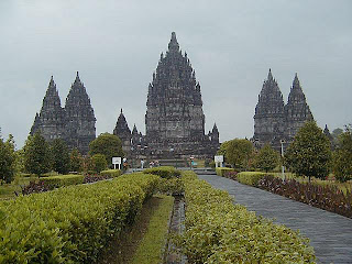
Prambanan, The Largest Hindu Temple
Prambanan is the ninth century Hindu temple compound in Central Java, Indonesia, dedicated to Trimurti, the expression of God as the Creator (Brahma), the Sustainer (Vishnu) and the Destroyer (Shiva). The temple compound located approximately 18 km east of Yogyakarta city on the boundary between Yogyakarta and Central Java province.
The temple is a UNESCO World Heritage Site, currently is the largest Hindu temple in Indonesia, and is one of the largest Hindu temples in south-east Asia. It is characterised by its tall and pointed architecture, typical of Hindu temple architecture, and by the towering 47m high central building inside a large complex of individual temples.
Prambanan is the largest Hindu temple of ancient Java, and the construction of this royal temple was probably started by Rakai Pikatan as the Hindu Sanjayas answer to the Buddhist Sailendra's Borobudur and Sewu temples nearby. The construction of Prambanan probably was meant to marked the return of Sanjaya dynasty to power after almost a century fell under Sailendra domination on Central Java.
A temple was first built at the site around 850 CE by either Rakai Pikatan or Balitung Maha Sambu the Sanjaya king of the Mataram Kingdom. According to Shivagrha inscription that wrote chandrasengkala ”Wwalung gunung sang wiku” (778 Saka/856 M), the temple was built to honor lord Shiva and the original name of the temple is Shiva-grha (the house of Shiva). Indeed, some archaeologists propose that the idol of Shiva in the garbhagriha (central chamber) of the main temple is modelled after King Balitung, serving as a depiction of his deified self after death.
The temple compound was expanded by successive Mataram kings such as Daksa and Tulodong with the addition hundreds of perwara temples around the chief temple. Prambanan served as the royal temple of the Hindu Kingdom of Mataram, with most of the state's religious ceremonies and sacrifices being conducted there. At the height of the Mataram kingdom, scholars estimate that hundreds of Brahmins with their disciples lived within the outer wall of the temple compound. The urban center and the court of Mataram were located nearby, somewhere in the Prambanan valley.
In the early 1990s the government removed the market that had sprung up near the temple and transformed the surrounding villages and rice paddies into an archaeological park. The park covers a large area, from Yogyakarta-Solo main road in the south, encompassing the whole Prambanan complex, the ruins of Lumbung and Bubrah temples, and as far as the Sewu temple compound in the north. In 1992 the Indonesian government created a State-owned Limited Liability Enterprise (PERSERO) of PT Taman Wisata Candi Borobudur, Prambanan, dan Ratu Boko. This enterprise is the authority for the park management of Borobudur Prambanan Ratu Boko and the surrounding region.
The open-air and indoor stages on the west side of the temple right across the Opak river, were built to stage the Ramayana ballet. This traditional Javanese dance is the centuries old dance of the Javanese court, performed every full moon night in the Prambanan temple since the 1960s. Since then, Prambanan has become one of the major archaeological and cultural tourism attractions in Indonesia.
After the reconstruction of the main temples in 1990s, Prambanan once again reclaim its status as an important religious center for Hindu rituals and ceremonies in Java. The religious significance revival of Prambanan was due to Balinese and Javanese Hindu communities in Yogyakarta and Central Java that annually perform their sacred ceremonies in Prambanan, such as Galungan, Tawur Kesanga, and Nyepi.
The temple was damaged during the May 2006 Java earthquake. Early photos suggest that although the complex was structurally intact, the damage was significant. Large pieces of debris, including carvings, were scattered over the ground. The temple has been closed to visitors until the damage can be fully assessed. The head of Yogyakarta Archaeological Conservation Agency stated that it would take months to identify the precise extent of the damage.However, some weeks later in 2006 the site had been re-opened for visitors. As of 2009, the interior of most of the temples remains off-limits for safety reasons.
Borobudur, The Exotic Largest Buddhist Temple
Borobudur is a ninth-century Mahayana Buddhist monument in Magelang, Central Java, Indonesia. The monument comprises six square platforms topped by three circular platforms, and is decorated with 2,672 relief panels and 504 Buddha statues.
A main dome, located at the center of the top platform, is surrounded by 72 Buddha statues seated inside perforated stupa. The monument is both a shrine to the Lord Buddha and a place for Buddhist pilgrimage. The journey for pilgrims begins at the base of the monument and follows a path circumambulating the monument while ascending to the top through the three levels of Buddhist cosmology, namely Kāmadhātu (the world of desire), Rupadhatu (the world of forms) and Arupadhatu (the world of formlessness). During the journey the monument guides the pilgrims through a system of stairways and corridors with 1,460 narrative relief panels on the wall and the balustrades.
Evidence suggests Borobudur was abandoned following the fourteenth century decline of Buddhist and Hindu kingdoms in Java, and the Javanese conversion to Islam. Worldwide knowledge of its existence was sparked in 1814 by Sir Thomas Stamford Raffles, the then British ruler of Java, who was advised of its location by native Indonesians. Borobudur has since been preserved through several restorations. The largest restoration project was undertaken between 1975 and 1982 by the Indonesian government and UNESCO, following which the monument was listed as a UNESCO World Heritage Site.Borobudur is still used for pilgrimage; once a year Buddhists in Indonesia celebrate Vesak at the monument, and Borobudur is Indonesia's single most visited tourist attraction.
Apart from the story of Buddhist cosmology carved in stone, Borobudur has many statues of various Buddhas. The cross-legged statues are seated in a lotus position and distributed on the five square platforms (the Rupadhatu level) as well as on the top platform (the Arupadhatu level).
Approximately 40 kilometers (25 mi) northwest of Yogyakarta, Borobudur is located in an elevated area between two twin volcanoes, Sundoro-Sumbing and Merbabu-Merapi, and two rivers, the Progo and the Elo. According to local myth, the area known as Kedu Plain is a Javanese 'sacred' place and has been dubbed 'the garden of Java' due to its high agricultural fertility. Besides Borobudur, there are other Buddhist and Hindu temples in the area, including the Prambanan temples compound. During the restoration in the early 1900s, it was discovered that three Buddhist temples in the region, Borobudur, Pawon and Mendut, are lined in one straight line position. It might be accidental, but the temples' alignment is in conjunction with a native folk tale that a long time ago, there was a brick-paved road from Borobudur to Mendut with walls on both sides. The three temples (Borobudur–Pawon–Mendut) have similar architecture and ornamentation derived from the same time period, which suggests that ritual relationship between the three temples, in order to have formed a sacred unity, must have existed, although exact ritual process is yet unknown.
Subscribe to:
Posts (Atom)